MH370 Malaysia Airlines on Google Maps – Has It Finally Been Found?
The disappearance of MH370 Malaysia Airlines on Google Maps on March 8, 2014, remains one of aviation’s most perplexing mysteries. Over the years, numerous theories and search efforts have emerged, with some individuals turning to Google Maps in hopes of locating the missing aircraft. This article delves into the role of Google Maps in the search for MH370 and examines recent claims suggesting the plane’s wreckage has been identified using this platform.
The Disappearance of Flight MH370
Flight MH370 departed from Kuala Lumpur International Airport bound for Beijing with 239 passengers and crew members on board. Approximately 40 minutes into the flight, the aircraft lost contact with air traffic control and vanished from radar screens. Despite extensive search operations covering vast areas of the Indian Ocean and beyond, the main wreckage has never been found, leading to widespread speculation and numerous conspiracy theories.
Google Maps and the Search for MH370
In the digital age, satellite imagery platforms like Google Maps have empowered the public to participate in search efforts for missing persons, vehicles, and even aircraft. Following the disappearance of MH370, online communities and amateur sleuths scoured Google Maps and Google Earth, hoping to spot clues that official searches might have missed.
One notable initiative was the use of the Tomnod platform, which allowed volunteers to examine satellite images for any signs of the missing plane. This crowdsourcing effort garnered significant attention, with millions participating in the search.
Claims of MH370 Wreckage Found on Google Maps
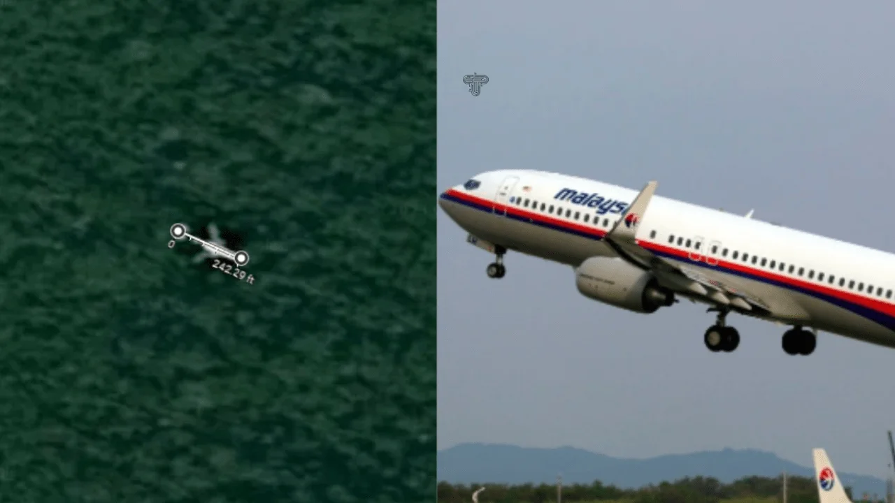
Over the years, several individuals have claimed to have spotted the wreckage of MH370 on Google Maps. In 2018, tech expert Ian Wilson asserted that he had identified the aircraft’s remains in the Cambodian jungle using Google Earth. Wilson stated, “Measuring the Google sighting, you’re looking at around 69 meters, but there looks to be a gap between the tail and the back of the plane.”
Similarly, in 2024, reports emerged of another tech expert claiming to have located the missing aircraft using Google Maps. These assertions, however, have not been substantiated by official investigations. Experts caution that while satellite imagery can be a valuable tool, it has limitations, including image resolution and the potential for visual anomalies that can be misinterpreted.
Official Search Efforts and Technological Advances
Despite the public’s enthusiasm and the occasional claims of discoveries via Google Maps, official search operations have relied on more sophisticated technology. Organizations like Ocean Infinity have deployed advanced underwater drones and sonar equipment to scour the ocean floor. In December 2024, Malaysia agreed to a $70 million deal with Ocean Infinity to resume the search for MH370, emphasizing the use of cutting-edge technology in these efforts.
Additionally, researchers have explored innovative methods to trace the aircraft’s final moments. For instance, a Cardiff University study analyzed underwater acoustic signals, suggesting that hydroacoustic technology could provide new insights into MH370’s fate.
Challenges in Using Google Maps for Aircraft Wreckage Identification
While Google Maps offers high-resolution satellite imagery accessible to the public, several challenges hinder its effectiveness in locating aircraft wreckage:
- Image Resolution and Clarity: Google Maps’ imagery, though detailed, may not capture small debris or objects obscured by natural elements like dense forest canopies or deep ocean waters.
- Temporal Limitations: Satellite images on Google Maps are not always up-to-date. The time lag between image captures can result in outdated visuals that miss recent changes or developments.
- Environmental Factors: Natural phenomena such as cloud cover, shadows, and seasonal changes can obscure or alter the appearance of objects, leading to potential misinterpretations.
- Geographical Challenges: Remote and rugged terrains, like dense jungles or deep-sea locations, pose significant obstacles to identifying and verifying potential wreckage sites via satellite imagery.
The Role of Crowdsourcing in Modern Search Efforts
The disappearance of MH370 highlighted the potential of crowdsourcing in search and rescue operations. Platforms like Tomnod enabled millions to participate in analyzing satellite imagery, demonstrating the power of collective effort. However, while crowdsourcing can supplement official searches, it cannot replace the precision and reliability of dedicated search technologies and expert analyses.
Tech Blaster
Conclusion
The quest to locate MH370 Malaysia Airlines on Google Maps continues, blending traditional search methods with modern technology and public participation. While Google Maps and similar platforms have democratized access to satellite imagery, enabling global involvement, they also present challenges that can lead to false leads and unverified claims. As search efforts advance, integrating cutting-edge technology, expert analysis, and international collaboration remains crucial in solving one of aviation’s greatest mysteries.